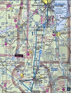
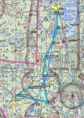
2026 Mass Arrival Flight Route
| Updated June 02, 2025 08:23 EDT |
Following is a Route Briefing that will answer most, if not all the questions you might have regarding our route to KOSH. To summarize, we will take off from runway 26, progress from "UNU26" (departure end of UNU runway 26) direct to waypoint "C2OWEST", fly over it, turn left and fly direct to waypoint "C2OSOUTH", fly over it, turn left and fly direct to waypoint "UNU20" (departure end of UNU runway 2), and fly over it. From this point we will fly direct to waypoint "RRINT" and follow the same route to Oshkosh that we've used every year for the past 15 plus years. Note that the waypoints are formatted in decimal degrees, easy to enter into Foreflight® and Garmin Pilot®. The total flight time from takeoff to the threshold of runway 36 at KOSH will be 34 minutes for the 90KIAS section and 30 minutes for the 110KIAS section.
Adherence to the briefed route and airspeed will ensure success.
This route briefing DOES NOT COUNT as our mission brief on Saturday, July 18, 2026. If you are not checked-in by 11:00:00 AM and seated for our mission brief by 1:00:00 PM, you will be removed from the flight roster. We would like to suggest that you bring your iPad® with your preferred E6B software to the mission brief.
We suggest that you load the enclosed flight plan to ForeFlight®, Garmin Pilot® or your preferred moving map software prior to the preflight brief. We have enclosed links to the actual Foreflight® and Garmin Pilot® flight plan files below. With all that done ahead of time, the mission brief can pass last minute info and we can get you out to your plane in a short time.
We are excited to see everyone in Juneau!
Blue Skies!

